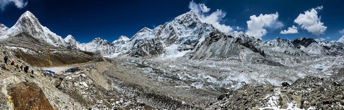
There is no viewpoint in the world quite like Kala Patthar. At 5,645 metres above sea level, the small rocky summit above Gorakshep delivers what is almost universally agreed to be the finest view of Mount Everest available to a non-technical hiker. From the top, you look directly across the Khumbu Glacier at the full southwest face of the world’s highest mountain — Everest’s famous pyramid summit rising above the Nuptse-Lhotse wall, with Pumori directly overhead and the labyrinth of the Khumbu Icefall visible below. No mountaineering equipment, no permits beyond the standard trekking documents, and no technical skills are required to stand there.
That said, reaching Kala Patthar is not simple. The summit is higher than any point in the Alps or Rockies. It requires 10–12 days of approach trekking, careful acclimatisation, and a pre-dawn ascent in temperatures that regularly fall below -15°C. This guide covers everything you need to know: the full ascent from Gorakshep, the timing strategies for optimal views, what you will actually see from the top, the weather and visibility variables, photography from the summit, how Kala Patthar compares to Everest Base Camp as a viewpoint, and the preparation required to make the most of this extraordinary vantage point. For the Everest Base Camp trek with Kala Patthar as its highlight, the summit view is the payoff for everything that comes before it.
What Is Kala Patthar? Name, Altitude, and Location
“Kala Patthar” is a Hindi and Nepali phrase meaning “black rock” — a reference to the dark-coloured slate and schist formation that makes up the prominent rocky ridge rising from the southern flank of Pumori. The name is appropriate: the ridge is distinctively dark against the white of the surrounding snowfields and glacier, making it recognisable from a distance as trekkers approach Gorakshep from below.
The altitude of Kala Patthar is sometimes quoted in different sources as either 5,545 metres or 5,645 metres. The discrepancy reflects the fact that the ridge has two main summits: the lower, more easily reached point at approximately 5,545 metres, and the true high point of the ridge at 5,645 metres. Most trekkers reach the lower point; some push to the higher summit if conditions, time, and energy allow. Both provide essentially the same view of Everest, though the higher summit adds slightly to the sense of achievement and provides a somewhat wider panorama.
Planning Your Everest Trek?
Get local expert advice on cost, itinerary and the best time to go.
Kala Patthar vs Everest Base Camp: Which Is the Better View?
| Comparison Factor | Kala Patthar (5,645m) | Everest Base Camp (5,364m) |
|---|---|---|
| View of Everest summit | Outstanding — direct line of sight to summit pyramid; full southwest face visible | Poor to none — the summit is hidden behind the Nuptse-Lhotse wall from Base Camp level |
| View of Khumbu Icefall | Excellent — looking down onto the icefall from above | Excellent — looking directly into the base of the icefall from ground level |
| View of surrounding peaks | 360-degree panorama: Pumori, Nuptse, Lhotse, Makalu, Cho Oyu, Changtse | Limited by moraine ridges; Pumori dominant; Everest summit hidden |
| Altitude | 5,645m | 5,364m |
| Difficulty of ascent from Gorakshep | 2–3 hours up; 1–1.5 hours down; steep final section | 2–3 hours return; flat to gently undulating moraine walk |
| What you find at the top | Rocky ridge with prayer flags; exposure to wind; no shelter | Cluster of cairns and prayer flags; relatively sheltered; expedition tents in season |
| Emotional impact | One of the world’s great viewpoints; seeing Everest clearly for the first time after 10 days is profound | Significant as a destination; many trekkers feel the EBC view underwhelms compared to the approach |
| Sunrise opportunity | Superb — Everest lit by first light with golden alpenglow; the world’s most iconic mountain photography opportunity | Less dramatic — moraine landscape without the elevated peak silhouette |
The honest assessment: Kala Patthar is the superior viewpoint by a large margin for anyone who wants to see Mount Everest. Everest Base Camp is the superior destination for those who want to stand at the foot of the mountain’s climbing routes and feel the scale of the place from ground level. Both experiences are valuable and complementary; most standard EBC itineraries visit both, typically going to EBC in the afternoon and Kala Patthar the following pre-dawn morning before the long descent back to Namche.
The Ascent from Gorakshep: Route, Duration, and Difficulty
The ascent of Kala Patthar begins from Gorakshep (5,164 metres), the last teahouse cluster on the main EBC trail. The route is straightforward but demanding at altitude. There is no technical climbing involved — the trail is a combination of rough path, scree, and rocky scrambling on the upper ridge — but at 5,500+ metres after a week of accumulated fatigue, what would be an easy hike at sea level becomes a significant physical challenge.
Step-by-Step Ascent Description
- Gorakshep to base of Kala Patthar (30–40 minutes): The trail leaves Gorakshep heading northwest, crossing a flat sandy/gravelly area that is the bed of the former glacial lake that gave Gorakshep its name. The route is marked by cairns and prayer flags. The ground is uneven and can be icy in early morning. Altitude: 5,164m to approximately 5,300m. Gradient: gentle to moderate.
- Base to lower ridge section (45–60 minutes): The trail begins to steepen significantly as it climbs the lower slopes of the Kala Patthar ridge. The ground becomes rockier, with loose shale and scree. Steps of varying height require careful foot placement. The first rest stop is typically a boulder-strewn shoulder at approximately 5,400m. At altitude, this section feels significantly harder than it looks — take it slowly, breathe deliberately, and pause regularly.
- Lower ridge to lower summit (30–45 minutes): The final climb to the lower summit (5,545m) is the steepest section of the ascent. The trail narrows to a rough path through scattered boulders. Some light scrambling — using hands for balance rather than for climbing — may be required in the final metres. The lower summit is marked by a cluster of prayer flags and cairns and provides the first full view of Everest’s summit.
- Lower summit to true high point (20–30 minutes for those continuing): The ridge continues northeast from the lower summit. This section is more exposed and requires more care with footing, particularly if there is frost or snow on the rock. The high point adds approximately 100 metres of altitude and provides a slightly wider panorama. Many trekkers, particularly those who have already been above 5,000m for several days, choose to stop at the lower summit.
| Ascent Section | Start Altitude | End Altitude | Duration (slow pace) | Terrain |
|---|---|---|---|---|
| Gorakshep to base of ridge | 5,164m | 5,300m | 30–40 minutes | Sandy flat, rough path, icy in morning |
| Base to lower ridge | 5,300m | 5,450m | 45–60 minutes | Steep rocky trail, loose shale, scree sections |
| Lower ridge to lower summit | 5,450m | 5,545m | 30–45 minutes | Boulder field, light scrambling, prayer flag climb |
| Lower summit to high point (optional) | 5,545m | 5,645m | 20–30 minutes | Exposed ridge, rocky, requires care in icy conditions |
| Total ascent (to lower summit) | 5,164m | 5,545m | 1h 45min – 2h 30min | Varies; most demanding at high altitude |
| Descent back to Gorakshep | 5,545m | 5,164m | 1h – 1h 30min | Same route; take care on icy morning descent |
Timing Strategy: When to Climb Kala Patthar
The timing of the Kala Patthar ascent significantly affects both the view and the experience. There are three distinct timing strategies, each with specific advantages and disadvantages:
Strategy 1: Pre-Dawn Departure (Most Popular)
Departing Gorakshep between 4:30am and 5:30am puts you near the summit at sunrise. This is by far the most popular approach and the one that produces the classic Kala Patthar photographs — Mount Everest’s summit pyramid lit by golden alpenglow while the valley below remains in deep shadow, the first light striking the highest point on earth while you watch from 5,545 metres above sea level.
The pre-dawn approach requires headlamps for the first hour of walking. The temperature at this hour will typically be between -10°C and -20°C, and the wind can add significant wind chill. The darkness means that footing requires more care than in daylight, and the dramatic temperature difference between the warm teahouse and the pre-dawn mountainside requires immediate layering at departure. Many trekkers find the discomfort of the pre-dawn departure the hardest part of the entire EBC trek, and many find the sunrise reward one of the most extraordinary moments of their lives.
Strategy 2: Early Morning Departure (Sunrise at Summit)
Departing at sunrise (approximately 6:00–6:30am depending on time of year) reaches the summit in full morning light. This avoids the pre-dawn cold and darkness but means the famous alpenglow sunrise view of Everest happens while you are still on the lower slopes rather than at the summit. The morning view from the summit is still superb — clear skies, good visibility, warming temperature — but does not include the iconic Everest alpenglow moment.
Strategy 3: Afternoon Ascent (Previous Evening Visit to EBC)
Some itineraries visit EBC in the afternoon of one day and then ascend Kala Patthar the following morning (pre-dawn or early morning). Others schedule Kala Patthar in the afternoon before or after the EBC visit. Afternoon visibility on Kala Patthar is significantly worse than morning visibility — cloud and mist typically build in the Khumbu from late morning onward, and by 2pm many days the upper ridges are obscured. If you can only do one morning visit, choose Kala Patthar morning and EBC afternoon.
| Timing Strategy | Departure Time | Summit Arrival | Temperature | Visibility | Best For |
|---|---|---|---|---|---|
| Pre-dawn (most popular) | 4:30–5:30am | ~6:30–7:30am (at sunrise) | -10°C to -20°C; very cold | Best possible — clear pre-dawn sky; golden sunrise alpenglow on Everest | Photographers; iconic sunrise experience; most memorable view |
| Early morning | 6:00–6:30am | ~8:00–9:00am | -5°C to -10°C; cold | Excellent — clear morning sky; no alpenglow but full daylight view | Trekkers who prioritise comfort over alpenglow; still superb view |
| Late morning | 8:00–9:00am | ~10:00–11:00am | 0°C to -5°C; manageable | Good but cloud beginning to build; Everest may be clear or partially obscured | Those with limited cold tolerance; less reliable view |
| Afternoon | 12:00–2:00pm | ~2:00–4:00pm | 0°C to 5°C; warmest option | Poor — cloud and mist typical; Everest summit often hidden | Not recommended for views; only if no other option |
The View from Kala Patthar: What You Will See
The panorama from Kala Patthar is one of the great mountain views of the world. Understanding what you are looking at — naming the peaks, understanding their relationships, appreciating the geology — transforms a collection of very large white shapes into a comprehensible landscape of extraordinary historical and geographical significance.
The Peaks Visible from Kala Patthar
| Peak | Altitude | Direction from Summit | Significance |
|---|---|---|---|
| Mount Everest (Sagarmatha / Chomolungma) | 8,848.86m | Northeast — directly across the Khumbu Glacier | Highest point on earth; southwest face and summit pyramid fully visible; the view that justifies the entire trek |
| Nuptse | 7,861m | East of Everest; forms the dominant wall of the Everest massif as seen from the south | The massive ridge of Nuptse is what hides Everest from Base Camp; from Kala Patthar, Everest is visible over the left end of the Nuptse ridge |
| Lhotse | 8,516m (4th highest) | Immediately right of Everest; connected by the South Col | Fourth highest mountain in the world; from Kala Patthar, its massive south face is fully visible; the South Col between Everest and Lhotse is the route of the standard Everest ascent |
| Pumori | 7,145m | Directly overhead (north-northwest) and very close — just 2km away | The dramatic peak directly above Gorakshep; Kala Patthar is on Pumori’s southeast ridge; the proximity of Pumori creates a sense of imminent scale that adds to the drama of the view |
| Changtse | 7,583m | North of Everest; on the Tibetan side of the border | The “North Peak” of the Everest massif; visible from Kala Patthar as the peak rising to the left of Everest’s summit when viewed from the south |
| Cho Oyu | 8,188m (6th highest) | Northwest — in the far distance beyond the Ngozumpa Glacier | The closest 8,000m peak to the EBC area; visible as a broad white summit mass on clear days to the northwest |
| Makalu | 8,463m (5th highest) | Southeast — distinctive four-sided pyramid | Fifth highest mountain in the world; recognisable by its distinctive pyramidal shape; visible on clear days to the southeast |
| Ama Dablam | 6,812m | South / southwest — below and behind on the descent | The most beautiful peak on the EBC trail; its dramatic ridged shape is visible on the descent rather than from the Kala Patthar summit, but provides the final view of the day |
The Khumbu Glacier: Reading the Ice from Above
From Kala Patthar, the full length of the upper Khumbu Glacier is visible stretching from the Khumbu Icefall below Everest down toward Gorakshep and beyond. The glacier is approximately 12 kilometres long and one of the most studied and most famous glaciers in the world — the source of significant glaciological research on climate change impacts in High Asia.
The Khumbu Icefall — the chaotic, heavily crevassed section of the glacier immediately above Base Camp — is clearly visible as a fractured white staircase leading from the base of the Western Cwm down to the flat area of Base Camp. This is the section that Everest climbers must cross daily in the expedition season, where seracs (towers of ice) the size of apartment buildings collapse without warning. From Kala Patthar at dawn in April, you can sometimes see the headlamps of climbers moving through the Icefall in the darkness below — one of the most surreal visual experiences on the entire trek.
Weather and Visibility: When Kala Patthar Is Clear
The visibility from Kala Patthar is entirely weather-dependent, and the Khumbu has some of the most rapidly changing mountain weather in the world. Understanding the weather patterns allows trekkers to make better decisions about timing and to manage expectations when conditions are less than ideal.
| Season | Typical Morning Visibility | Typical Afternoon Visibility | Wind Conditions | Temperature at Summit | Recommendation |
|---|---|---|---|---|---|
| Spring (March–May) | Excellent — clear crystal skies most mornings; jet stream retreating northward | Variable — cloud builds from mid-morning; clear days becoming less reliable by May | Generally lighter than autumn; jet stream wind events possible in March | -5°C to -15°C at dawn | Best spring months: April and early May; summit attempts possible nearly every morning in April |
| Monsoon (June–August) | Poor — cloud, rain, and reduced visibility; occasional early morning windows | Very poor — consistent cloud cover | Moderate; wet conditions add risk on rock | 0°C to -5°C | Not recommended for Kala Patthar; significant chance of missing the view entirely |
| Autumn (September–November) | Excellent — post-monsoon clarity produces the best visibility of the year; skies almost cobalt blue | Variable — less afternoon cloud than spring; October generally clearest month | Stronger than spring; cold fronts can produce dangerous wind above 5,000m in late November | -10°C to -20°C at dawn from October onward | Best autumn months: October and early November; the view in late October is arguably the finest of any season |
| Winter (December–February) | Good when clear; long periods of high pressure produce excellent clarity | Good — less convective cloud in winter | Very strong — sustained gale-force winds possible at summit; high wind chill risk | -15°C to -30°C; potentially life-threatening with wind | Possible for experienced cold-weather trekkers only; wind risk must be assessed on the day |
The Jet Stream and Its Effect on Kala Patthar Visibility
The jet stream — the fast-moving high-altitude air current that circles the globe — runs directly over the Himalaya for much of the year, particularly from December through March. When the jet stream is positioned over Everest, the summit cloud (the “plume” visible from Kala Patthar as a banner of wind-driven ice crystals extending from the summit) indicates wind speeds at the summit exceeding 200km/h. The jet stream does not significantly affect the lower-altitude conditions at Kala Patthar, but when it is active, the visual drama of Everest’s summit plume is remarkable — a continuous horizontal cloud extending for kilometres from the highest point on earth.
The spring climbing season (April–May) is timed to coincide with the jet stream’s seasonal retreat northward, which opens a brief window of calmer weather at the summit that allows safe ascent. By late April and May, Kala Patthar views of Everest often show the summit without the plume — indicating summit conditions calmer than the stormy winter. Watching for the presence or absence of the plume from Kala Patthar is one of the more dramatic ways to appreciate the extreme conditions that Everest climbers must navigate.
Photography from Kala Patthar: A Complete Guide
Kala Patthar is one of the world’s great photography locations — a high-altitude vantage point with clear air, dramatic subjects, and the quality of light that only exists above 5,000 metres. Capturing it well requires specific equipment and technique considerations that differ from lower-altitude photography.
Equipment Recommendations
- Telephoto zoom lens: A focal length of 100–400mm brings Everest’s summit detail to life — ice formations, the Hillary Step, the plume, and climbers in expedition season. A wide-to-telephoto zoom (24–200mm equivalent) is the practical compromise if you cannot carry two lens systems.
- Wide-angle lens: A wide-angle (16–24mm equivalent) captures the full 360-degree panorama including the Pumori face directly overhead and the vast depth of the glacier below. Essential for landscape compositions.
- Spare batteries: At -15°C, camera batteries lose 30–50% of their capacity. Carry 2–3 spare batteries kept warm in an inner pocket; rotate them during the ascent.
- Tripod or monopod: At altitude with altitude-related fatigue and potentially cold hands, camera shake is a real issue. A lightweight carbon fibre tripod or monopod significantly improves sharpness in low-light pre-dawn conditions.
- UV filter: Protects the front element from fine sand and grit that blows at altitude.
- Lens cloth: Cold optics fog when taken into warm conditions. Carry a microfibre cloth to clear condensation from the lens.
Photographic Timing: The Light Sequence at Kala Patthar
| Time Before/After Sunrise | Light Quality | Best Subject | Technical Notes |
|---|---|---|---|
| 60 min before sunrise | Astronomical twilight; deep blue; stars visible | Milky Way over Everest; headlamp silhouettes | 20–30 sec exposure; ISO 3200–6400; f/2.8 |
| 30 min before sunrise | Nautical twilight; deep blue-purple; Everest visible | Everest silhouette against pre-dawn sky | 2–10 sec; ISO 800–1600 |
| 15 min before sunrise | Civil twilight; pink-orange on horizon | Horizon colour; peak silhouettes | ISO 400–800; 0.25–2 seconds |
| Sunrise + 5 minutes | ALPENGLOW — golden-orange on summit pyramid | Iconic shot: gold Everest against blue sky | ISO 100–400; 1/60–1/250 sec; bracket exposures |
| Sunrise + 20 minutes | Full sunrise; harsh shadows beginning | Peak panoramas; glacier detail; prayer flags | ISO 100–200; 1/250–1/1000 sec |
| Sunrise + 1 hour | Full morning light; excellent clarity | Detail shots; wide-angle panoramas | ISO 100; 1/500–1/1000 sec; polarising filter |
What to Wear on the Kala Patthar Ascent
The temperature range on the Kala Patthar ascent is extreme by any standard. You leave Gorakshep in pre-dawn cold of -10°C to -20°C, and by the time you descend in late morning it may have risen to 0°C or above. The layering system must accommodate this range while managing sweat accumulation during the ascent and wind exposure on the exposed summit ridge.
| Layer | Item | Function | Notes |
|---|---|---|---|
| Base layer (top) | Merino wool or synthetic thermal top | Moisture wicking; insulation | Do not wear cotton |
| Mid layer | Fleece or softshell jacket | Insulation; some wind protection | Removable during hard ascent sections |
| Outer insulation | Down jacket (800 fill power) | Primary insulation in extreme cold | Worn at rest and at summit; stow in pack during climbing |
| Shell layer | Hardshell or windproof jacket | Wind protection on exposed ridge | Critical — summit wind can be lethal without this |
| Legs | Thermal base layer + softshell pants | Leg insulation; knee protection | Waterproof over-trousers if snow possible |
| Hands | Thin glove liner + expedition mittens | Dexterity for camera plus warmth | Mittens essential; gloves alone not enough at -15°C |
| Head | Balaclava + warm hat + buff | Heat retention; wind protection on face | 25–40% heat lost from head; full face coverage in wind |
| Feet | Merino wool socks (2 pairs) + waterproof boots | Insulation; ankle support | Microspikes if icy; gaiters in snow |
| Eyes | Category 4 glacier glasses or goggles | UV and wind protection | UV doubles at 5,500m; risk of snow blindness without protection |
Acclimatisation Requirements Before Attempting Kala Patthar
Kala Patthar is not a summit attempt in the mountaineering sense, but at 5,645 metres it is higher than the highest non-climbing point reachable without supplemental oxygen outside the Himalaya. The acclimatisation requirements are real and should not be dismissed.
- Day 1–2 (Lukla to Namche, 2,860–3,440m): First altitude increase; mild symptoms common and expected
- Day 3 (Namche acclimatisation, sleep 3,440m / hike 3,880m): First “climb high, sleep low” day; critical for establishing acclimatisation baseline
- Day 4–5 (Namche to Dingboche, 3,440–4,410m): Crossing 4,000m; breathlessness becomes normal; pace reduction required
- Day 6 (Dingboche acclimatisation, sleep 4,410m / hike 4,980m): Second major acclimatisation day; reaching 4,980m prepares the body for 5,000m+ exposure
- Day 7 (Dingboche to Lobuche, 4,940m): Extended time above 4,500m; accumulating high-altitude days
- Day 8 (Lobuche to Gorakshep to EBC, 5,164–5,364m): First night above 5,000m; EBC visit establishes high-altitude comfort
- Day 9 (Kala Patthar pre-dawn, 5,645m): The accumulated acclimatisation of 8 previous days makes this achievable; attempting without this progression would be significantly more dangerous
- Day 1–2 (Lukla to Namche, 2,860–3,440m): First altitude increase; mild symptoms common and expected
- Day 3 (Namche acclimatisation, 3,440m sleep / 3,880m hike): First “climb high, sleep low” day; critical for establishing acclimatisation baseline
- Day 4–5 (Namche to Tengboche to Dingboche, 3,440–4,410m): Crossing 4,000m; breathlessness becomes normal; pace reduction required
- Day 6 (Dingboche acclimatisation, 4,410m sleep / 4,980m hike): Second major acclimatisation day; reaching 4,980m prepares the body for 5,000m+ exposure
- Day 7 (Dingboche to Lobuche, 4,410–4,940m): Extended time above 4,500m; accumulating high-altitude days
- Day 8 (Lobuche to Gorakshep to EBC, 4,940–5,364m): First night above 5,000m (at Gorakshep); EBC visit establishes high-altitude comfort
- Day 9 (Kala Patthar pre-dawn, to 5,645m): The accumulated acclimatisation of the previous 8 days makes this achievable; attempting without this progression would be significantly more dangerous
The Emotional Experience: What Trekkers Actually Feel at the Top
Reading technical information about Kala Patthar prepares you for the logistics of the ascent. Nothing entirely prepares you for how it feels to stand there in the pre-dawn cold with the world’s highest mountain glowing gold a few kilometres away.
The most commonly reported emotional responses include a combination of awe and overwhelm at the scale of the surrounding mountains — Pumori filling the sky directly overhead, Everest larger and more immediate than any photograph suggests, the Khumbu Glacier stretching out below like a frozen river. There is exhaustion from both the physical ascent and the 9 days of accumulated trekking, which heightens the emotional sensitivity that altitude already produces. There is sometimes unexpected emotion — tears are common, reported by trekkers of all temperaments and in diaries and trip reports from every nationality that treks this route.
There is also, often, a sense of perspective that comes from being at altitude with a physical reality that cannot be disputed. The mountain is simply there, exactly as large and cold and indifferent as the whole world of human concern that you left behind 9 days ago. Many trekkers describe the Kala Patthar summit as a moment of clarity — about what matters, about the relative scale of the things they worry about, about the value of putting yourself in places that require genuine effort to reach. This is not sentimentality; it is a commonly reported and apparently genuine psychological effect of high-altitude mountain exposure that has been documented in trekking literature for decades.
Frequently Asked Questions About Kala Patthar
How difficult is the ascent compared to the rest of the EBC trek?
The Kala Patthar ascent is widely considered the single hardest effort of the EBC trek, concentrated into 2–3 hours rather than spread across a full day. The altitude (you are above 5,500m), the accumulated fatigue from 8–9 previous trekking days, the pre-dawn cold, and the steep final section combine to make it more demanding per hour than any other section of the route. However, because it is short (2–3 hours up), the total energy expenditure is manageable for anyone who has been able to complete the previous days of the trek without significant difficulty.
Can you see Everest’s summit from Everest Base Camp?
No. This surprises many trekkers who assume Base Camp is directly below the summit with clear sightlines. In reality, Everest’s summit is hidden from Base Camp by the Nuptse-Lhotse ridge wall. From Base Camp you can see the Khumbu Icefall, the beginning of the Western Cwm, and the lower flanks of Everest, but the summit is not visible. This is why Kala Patthar is the genuine Everest viewpoint destination, while EBC offers a different (and also valuable) experience of being at the foot of the climbing route.
Is a permit required specifically for Kala Patthar?
No separate permit is required for Kala Patthar beyond the standard Sagarmatha National Park entry permit and TIMS card that all EBC trekkers obtain. Kala Patthar is within the national park and covered by the standard entry permit. There is no summit registration or peak permit required — it is a trekking summit, not a technical climbing peak.
Kala Patthar is the moment that the Everest Trek Company EBC route exists to deliver. All the acclimatisation planning, the itinerary design, the guide training, and the logistics that go into a professionally organised EBC trek converge on this pre-dawn moment: standing above the Khumbu Glacier with the world’s highest mountain filling your field of view in golden morning light. No photograph, no documentary, and no description in any guide captures it fully. The only way to understand it is to go.
Comparing Kala Patthar Across Trek Seasons: Month-by-Month Guide
| Month | Weather at Summit | Visibility | Trail Conditions | Crowd Level | Overall Rating |
|---|---|---|---|---|---|
| January | Very cold (-20°C to -30°C); strong winds likely | Excellent on clear days | Snow and ice on upper sections; crampons often needed | Very low | Challenging; for experienced cold-weather trekkers only |
| February | Bitterly cold; wind events possible | Very good | Snow on trail; icy | Low | Difficult; possible with proper gear and experience |
| March | Cold (-15°C to -20°C); improving as month progresses | Good; some high cloud | Snow melting; variable | Low to moderate | Early shoulder season; improving conditions |
| April | Cold (-10°C to -15°C at dawn); warming through day | Excellent — the classic spring clarity | Good; minimal snow on trail | High (peak spring season) | Best spring month; ideal conditions; expedition season views |
| May | Cold to mild (-5°C to -12°C at dawn) | Good early month; afternoon cloud increasing | Very good; dry trail | Very high (peak) | Excellent views but busiest month |
| June | Mild at altitude; variable | Poor; pre-monsoon cloud building | Trail conditions good but visibility low | Low | Not recommended; significant cloud risk |
| July | Mild; monsoon active | Very poor; cloud and precipitation | Wet; leeches lower sections | Very low | Avoid unless embracing the challenge |
| August | Mild; monsoon continuing | Poor; intermittent cloud | Wet; some improvement late month | Low | Only late August worth considering |
| September | Cool (-5°C to -10°C at dawn) | Very good — post-monsoon improving | Good; some residual moisture | Moderate (building) | Good; views improving rapidly as monsoon clears |
| October | Cold (-10°C to -15°C at dawn) | Outstanding — widely considered the best month | Excellent; dry; clear | Very high (peak autumn) | The finest month for Kala Patthar; crystal views in all directions |
| November | Very cold (-15°C to -20°C); wind increasing | Excellent early month; wind events late month | Good; some early snow possible late month | Moderate to high (early); decreasing late | Early November excellent; late November increasingly demanding |
| December | Very cold; strong winds possible | Good on calm days | Snow on upper sections | Low | Demanding but possible; cold-weather preparation essential |
Kala Patthar for Different Types of Trekkers
First-Time Himalayan Trekkers
For someone doing their first Himalayan trek, Kala Patthar will be among the most demanding physical challenges they have ever undertaken — and likely among the most rewarding. The key preparation is honest fitness assessment and 8–12 weeks of specific training before departure. Running, cycling, or swimming 4–5 days per week at moderate intensity; hiking on weekends with a loaded pack; stair climbing sessions (not a replacement for real trail, but excellent for the sustained uphill demand of the EBC route). Arrive in Kathmandu with 3–4 days of buffer before flying to Lukla to recover from jet lag and explore the city at 1,400m. Follow the acclimatisation itinerary precisely — do not rush because you feel good.
Experienced Himalayan Trekkers
If you have previously trekked to 4,000–5,000m with no significant AMS, you are likely to find Kala Patthar manageable with appropriate preparation. Consider extending your summit attempt to the true high point at 5,645m rather than stopping at the lower summit. Experienced trekkers who respond well to altitude can also consider the Three Passes circuit as an alternative to the standard EBC out-and-back, which allows approaches to Kala Patthar from different directions.
Senior Trekkers (60+)
Hundreds of trekkers in their 60s, 70s, and older reach Kala Patthar every year. The factors that matter most are cardiovascular fitness, joint health (particularly knees for the long descents), and medical clearance from a doctor explicitly briefed on high-altitude exposure above 5,000 metres. Add at least two extra acclimatisation days to the standard 12-day itinerary. Carry a pulse oximeter and take SpO2 readings morning and evening.
Solo Trekkers
The pre-dawn Kala Patthar ascent is particularly well-suited to solo trekking — the headlamp ascent in the dark, arriving at the summit to an ever-widening view, the solitude of being one of the few people there as the mountain turns gold. Solo trekkers should use a headlamp with fresh batteries, use trekking poles on the rocky trail, and tell their teahouse host what time they are departing and when to expect them back. A Garmin InReach or similar satellite communicator is particularly valuable for solo trekkers on the pre-dawn ascent.
The pre-dawn Kala Patthar ascent is particularly well-suited to solo trekking — the headlamp ascent in the dark, arriving at the summit to an ever-widening view, the solitude of being one of the few people there as the mountain turns gold. Solo trekkers should use a headlamp with fresh batteries, use trekking poles on the rocky trail, and tell their teahouse host what time they are departing and when to expect them back. A Garmin InReach satellite communicator is particularly valuable for solo trekkers on the pre-dawn ascent when the trail is dark, cold, and empty.
The History of Kala Patthar as a Viewpoint
Kala Patthar first appears in expedition accounts as a reconnaissance position in the early 1950s. The 1951 Eric Shipton reconnaissance expedition, which first identified the Khumbu Glacier as a potential ascent route for the southwest face of Everest, passed through the Gorakshep area. Subsequent expeditions used the elevated position of what is now called Kala Patthar to photograph and survey the Khumbu Icefall and Western Cwm.
The establishment of regular trekking to Everest Base Camp in the late 1960s and 1970s — enabled by the construction of Lukla airstrip in 1964 by Sir Edmund Hillary’s Himalayan Trust — brought recreational trekkers to the Gorakshep area for the first time. Kala Patthar became recognised among early trekkers as offering the definitive view of Everest that Base Camp itself could not provide. By the 1980s, it was a standard addition to EBC itineraries. Today it is the summit that the majority of EBC trekkers include in their trek.
Kala Patthar vs Gokyo Ri: Which Is the Better Everest View?
Gokyo Ri (5,357m) above the Gokyo Lakes in the neighbouring Ngozumpa Glacier valley is sometimes mentioned as an alternative Everest viewpoint. Both summits offer views of Everest, but the character and quality of those views differ significantly.
| Factor | Kala Patthar (5,645m) | Gokyo Ri (5,357m) |
|---|---|---|
| Proximity to Everest | ~7km line-of-sight | ~20km line-of-sight |
| View of Everest | Outstanding close view; summit pyramid clearly detailed; entire southwest face visible | Good but more distant; Everest is one of several 8,000m peaks visible |
| Panorama | Strong on the Everest massif and Khumbu Glacier; Pumori dominates directly overhead | Outstanding 360-degree view including Cho Oyu, Makalu, Lhotse, Everest, and the Gokyo Lakes directly below |
| Gokyo Lakes view | None — wrong valley | Superb — turquoise lakes from above is one of the most beautiful views in the Khumbu |
| Ascent difficulty | Steeper; more demanding; higher altitude | Steep but shorter; slightly lower altitude |
| Best for | Closest, most detailed Everest summit view available to non-climbers | Fuller panoramic Khumbu overview including glaciers and lakes |
Common Mistakes on the Kala Patthar Ascent
- Leaving Gorakshep without adequate clothing: The most common and dangerous mistake. Trekkers underestimate the wind chill at 5,500m in the pre-dawn hours. Pack your full cold-weather system — balaclava, expedition mittens, windproof layer — even if it seems like too much at 4am in the teahouse.
- Starting too late: Leaving Gorakshep after 6am significantly increases the risk of the summit being in cloud. The pre-dawn start is cold and uncomfortable; it is also overwhelmingly likely to give you the clear view that the later start may miss.
- Moving too fast on the lower slopes: Altitude-related fatigue accumulates. Trekkers who push hard in the first hour to stay warm often hit the wall on the steep upper section. Deliberately slow pace conserves oxygen for the upper ridge.
- Not eating or drinking before departure: Carry snacks (energy bars, nuts, chocolate) and a thermos of warm liquid. Dehydration and low blood sugar at altitude contribute to worsening AMS on the summit ascent.
- Not turning back when warranted: A headache that worsens with altitude gain, confusion, or severe breathlessness at rest are all reasons to turn around, regardless of how close the summit seems.
- Forgetting camera batteries: Store all camera batteries warm inside your sleeping bag overnight. Cold can reduce rated battery life by 30-50%.
The Three Passes trek combines both Gokyo Ri and Kala Patthar on a single itinerary and is recommended for trekkers who want the fullest Khumbu panoramic experience. The EBC classic route focuses on Kala Patthar specifically because it offers the most detailed and dramatic close-up view of Everest itself — which is, for most trekkers, the primary motivation for the entire journey.
After Kala Patthar: The Descent and What Comes Next
The descent from Kala Patthar back to Gorakshep takes 60–90 minutes. Most trekkers feel significantly warmer and more energised on the descent than they did on the ascent — the combination of the summit reward, increasing daylight, and descending altitude all contribute. Take care on the steep rocky section in the upper descent; tired legs on loose scree cause the majority of falls on this section.
After returning to Gorakshep for breakfast, the standard itinerary begins the long descent back toward Namche Bazaar — a full day of 1,800+ metres of descending. This section is physically demanding in a way that is qualitatively different from the ascent. The repeated eccentric loading of downhill travel stresses quadriceps and knee joints in ways that can be extremely painful without specific preparation. Trekking poles are essential. Take regular breaks. Accept that slow, controlled descent is faster than fast descent followed by injury.
Many trekkers describe the first hours after Kala Patthar as a strange combination of emotional completion and physical depletion. The summit was the goal; everything from here is the journey home. Ama Dablam reappears on the horizon as you descend toward Pangboche, Tengboche monastery reappears with the late afternoon light on its gold roofs, and the rhododendron forests of the lower Khumbu close back in around you as you drop below 3,800 metres. The descent is, in its own way, as beautiful as the ascent — you are moving through the same extraordinary landscape with the summit already banked, heading home.
Responsible Trekking on Kala Patthar
- Pack out all waste: Do not leave food wrappers, tissue paper, or any other solid waste on the trail or at the summit. The summit area has suffered from litter accumulation in high-season years; every individual’s pack-out behaviour directly improves the situation.
- Do not disturb prayer flags or cairns: The prayer flags at the summit are religious offerings placed by Sherpa porters, guides, and locals. The summit cairns are fragile structures built over decades; dismantling them for photograph compositions is disrespectful and damages cultural heritage.
- Stay on the trail: Soil and vegetation communities at 5,000m+ are extremely fragile. Recovery from trampling takes decades at these elevations. Do not cut switchbacks or create new paths.
- Water: Carry all water from Gorakshep for the ascent. Descend with any empty containers for refilling and filtration at the teahouse.
- Noise: The pre-dawn summit is a place of extraordinary quiet. The majority of people there have waited years to stand in that place and hear nothing but the wind on the ridge. Consider what kind of presence you want to bring to the summit.
Practical Information Summary
| Item | Detail |
|---|---|
| Summit altitude | 5,645m (true high point); 5,545m (lower, commonly reached point) |
| Starting point | Gorakshep, 5,164m |
| Ascent time | 1h 45min – 2h 30min to lower summit; add 20–30 min for true high point |
| Descent time | 1h – 1h 30min back to Gorakshep |
| Best timing | Pre-dawn departure (4:30–5:30am) for sunrise alpenglow on Everest |
| Required permits | Sagarmatha National Park permit (NPR 3,000) + TIMS card — no additional summit permit |
| Essential gear | Headlamp, expedition mittens, balaclava, windproof layer, trekking poles, glacier glasses, warm thermos, spare camera battery |
| Best season | October (autumn) and April (spring) |
| Technical difficulty | None — non-technical trekking; occasional light scrambling on upper ridge |
| Accommodation | Gorakshep teahouses (basic; limited rooms; book ahead in peak season) |
More Frequently Asked Questions
Do I need to hire a guide specifically for the Kala Patthar ascent?
Since 2023, Nepal’s government has made guides compulsory for all EBC trekkers, so you will have a guide for the entire trek including Kala Patthar. A guide on the pre-dawn ascent provides navigational support in the dark, emergency assistance if a member of the group develops symptoms, familiarity with terrain and weather conditions, and cultural context. Many trekkers find the guide’s local knowledge adds significantly to the summit experience — your guide can name every peak visible from the top and share the Sherpa perspective on the landscape that surrounds their home villages.
How cold is it really at the summit?
In October (the most popular month), the pre-dawn temperature at Kala Patthar summit is typically between -10°C and -18°C, with wind chill potentially bringing the effective temperature to -25°C or lower on exposed ridge sections. In April, the range is slightly warmer: -8°C to -15°C. The difference between standing in -15°C wind in inappropriate clothing versus appropriate clothing is the difference between a miserable, potentially dangerous experience and a cold but manageable one. Invest in the gear before the trek; rent supplementary items in Kathmandu or Namche if you do not want to buy.
What time does sunrise happen at Kala Patthar?
In October, sunrise is approximately 6:00–6:15am local time. In April, approximately 5:45am. Civil twilight (when it is light enough to see the mountains clearly) begins about 30 minutes before this. The alpenglow on Everest’s summit typically begins 5–10 minutes before the sun clears the horizon. To be at the summit for this moment, count back 2 hours from the target summit time to determine your Gorakshep departure time.
Can I reach Kala Patthar without doing the full EBC route?
In theory yes — you could fly to Lukla, trek to Gorakshep, and ascend Kala Patthar without visiting EBC. In practice, the acclimatisation requirements for a safe ascent to 5,645m are identical whether your destination is EBC, Kala Patthar, or both. You still need the same gradual altitude gain over 8–10 days. There is no meaningful shortcut.
What trekkers say about their experience
Reading the accounts of people who have stood on Kala Patthar reveals a consistency of response that transcends nationality, age, and prior mountain experience. A retired teacher from Germany who trekked in her 68th year described the pre-dawn arrival as “the moment I understood why people dedicate their lives to mountains.” A 34-year-old software engineer from California described the view as “the only time in my adult life I have cried from beauty.” A Nepali trekking guide who has been to the summit more than 100 times says it never becomes routine — “the mountain always shows you something different.”
What is consistent across these accounts is not the specific visual details — every visit in different weather, different season, different light produces a different experience — but the sense of earned perspective. The 10 days of walking that precede Kala Patthar are not incidental to the experience; they are constitutive of it. The summit means something because the trail to it demanded something. This is the truth at the heart of why Kala Patthar continues to draw trekkers from every country in the world, year after year. Planning your own Everest Base Camp trek means planning for this moment — and everything that leads up to it.
Planning Your Everest Trek?
Get local expert advice on cost, itinerary and the best time to go.